The sand is vanishing faster than the community can react — and now, new 3D maps show just how much of Buxton’s beach has been erased.
In just five stormy weeks, the shoreline here lost the equivalent of 800 dump trucks of sand and nearly nine feet of elevation, according to new data from RCOAST, a North Carolina-based coastal research firm. The findings reveal an unprecedented rate of erosion that scientists say has left the beach “drowning.”
Other WRAL Top Stories
“This is the highest erosion rate we’ve ever measured, hands down,” said Christy Swann, founder of RCOAST. “The shoreline just hasn’t had time to recover between storms. It’s a super-weakened and vulnerable system.”
Swann’s team uses high-resolution 3D mapping to track changes in the beach’s elevation and footprint, data that can pinpoint exactly where and how fast the land is retreating. After back-to-back tropical systems pummeled Buxton this fall, those maps show a beach collapsing in real time.
“You can think of it like being caught in waves that never stop coming,” Swann said. “The beach hasn’t had time to come up for air.”
A coastline running out of breath
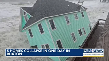
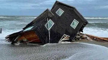
The series of storms, from Hurricane Erin to Humberto, didn’t just knock down homes. They stripped away the foundation beneath them — the vertical support that kept oceanfront structures stable. As the beach dropped nearly a story in elevation, the ground beneath homes crumbled into the surf.
Sixteen houses have fallen into the Atlantic since mid-September, each collapse scattering debris for miles and forcing federal cleanup crews to shut down stretches of Hatteras Island.
More are teetering on the Edge.
"We have several threatened oceanfront structures that are in a state of potential imminent collapse,” said Dave Hallac, superintendent of the Cape Hatteras National Seashore.
The human hand behind the loss
Swann says Buxton’s collapse can’t be blamed on one factor alone. Natural barrier islands are meant to move, but decades of development, highway construction, and now accelerating climate change have pushed that process into overdrive.
“Sea level rise and stronger storms are absolutely accelerating what’s already happening,” Swann said. “But the bigger issue is how we’ve built and how we’ve trapped sediment in a system that depends on movement.”
Humans have been drawing permanent lines in impermanent places. Roads like Highway 12, built to connect fragile barrier islands, now act as hard barriers that block dunes from migrating inland. Rivers that once carried sediment to the coast are dammed upstream. And homes still rise on top of sand, the most mobile substance in nature.
“The system is starved,” Swann said. “We’ve cut off its sediment supply and then demanded that it stay in place. You can tell nature to do that, but it’s going to do whatever it wants.”
That imbalance, she says, has turned Buxton into “a case study in maladaptation” — a place where scientists say efforts to protect infrastructure are actually accelerating its destruction.
Former Dare County commissioner Danny Couch, a lifelong Hatteras resident, said the community feels trapped between tides and bureaucracy.
“Everybody tends to pass the buck,” Couch said. “The county says it’s the state’s issue, the state says it’s federal, the feds say it’s not theirs. Meanwhile, we’re out here picking up the pieces.”
Sandbags and hard choices
In recent months, residents and business owners have tried to shield homes with sandbags, hoping to buy time until Dare County’s $45 million beach nourishment project begins next spring. But Swann’s data shows that those makeshift fixes may worsen erosion nearby.
“When you put sandbags in front of one property, you can actually create more erosion around it,” she said. “That’s not good for the adjacent homes. Coastlines like to be straight, and when you make them bumpy, you accelerate erosion at the edges.”
It’s a dynamic seen in other coastal states, where hard armoring such as walls and bulkheads can protect one stretch of beach while starving another. “North Carolina banned most hard structures for a reason,” Swann said. “The goal was to protect the coast as a whole, not one house at a time.”
But that policy leaves communities like Buxton with few options. County Manager Robert Outten said Dare County has the funds and contracts ready for nourishment but can’t move faster than nature, or bureaucracy, allows.
“We plan in five-year cycles,” Outten said. “Buxton has sped up to about three. We’ll add more sand this time and hope to get back on schedule.”
Swann worries that timeline may be too slow. “They’re making good plans, but Buxton doesn’t have time,” she said. “We’re heading into nor’easter season, and the beach is incredibly vulnerable. More homes are going to go before the mitigation even starts.
The interactive map above shows the shoreline in Buxton, North Carolina. The picture on the left shows the shoreline on Oct. 8, 2023. Use the slider tool on the picture to see how the shoreline has moved west. The picture on the right depicts the area as of Oct. 4, 2025. It shows how several homes have collapsed into the Atlantic.